C4ISR · AI battle management
ZEEL NET
AI battle management. Every sensor on one live map, and every detection turned into a decision in minutes.
- Data
- UAV, aerial, satellite, SAR
- AI
- Detection, change detection
- Picture
- One live map
Capabilities
From raw imagery to detected threats
Data ingestion
Real-time streams from aircraft and UAVs, aerial photography, satellite and SAR imagery, and video from fixed locations.
Processing and storage
Imagery is orthorectified, and detailed UAV imagery is layered with satellite and SAR on one live map.
AI object detection
In detailed UAV and satellite imagery, armor, artillery and vehicle columns are picked out automatically, across terrain, season and cover.
Change detection
New clearings, earthworks and tracks are outlined by comparing fresh coverage with an earlier pass, even in low-resolution satellite imagery.
Situational awareness
Live tactical maps of troop movements and detections, shared across units.
Planning and tasking
Recon and surveillance missions are planned, and tasks sent, from the tactical map.
Intelligence
From imagery to the picture
01
Ingest and orthorectify
Streams and imagery arrive and are orthorectified onto the live map.
02
Detect and classify
AI detects military infrastructure and equipment and estimates the threat level.
03
Review
Analysts go through each detection with a full set of review tools, and confirm or reject it.
04
Share
Confirmed detections join the collaborative tactical map, with unit alerts.
05
Task
Recon and observation tasks go out from the same map, and field terminals receive the updated points.
Tactical map
Built for commanders, not data scientists
Live tactical maps show troop movements and detections. Maps are collaborative, with data sharing and export, and units keep their own maps with versions.
- MIL-STD-2525D symbology, with national symbol sets
- Tactical graphics: front line, boundaries by echelon, observation areas
- 2D map and 3D terrain, with elevation under the cursor
- Distance, area and terrain-following measurement, and elevation profiles
- Range sectors and distance to the front line
- Collaborative maps, data sharing and export
- Print-ready map exports at any paper size
Object detection
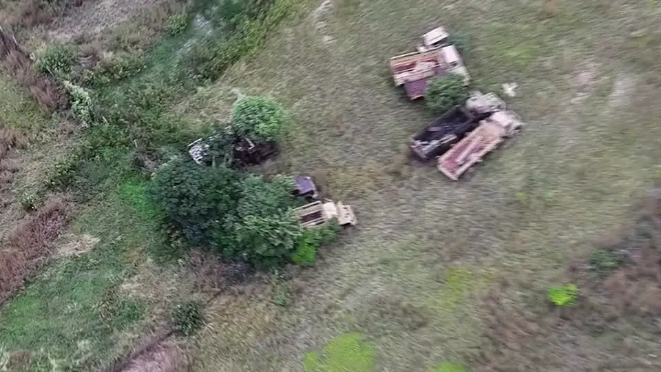
Every vehicle in the footage, found and checked
Hours of drone footage are reviewed automatically, so operators see only what matters. In detailed imagery from UAV flights or high-resolution satellites, armor, artillery and vehicle columns are picked out across terrain, season and cover, then confirmed or rejected by an analyst.
- Works on UAV video and stills, and high-resolution satellite imagery
- Detection of military equipment and infrastructure
- Classification and threat-level estimation, with a confidence score
- Full review and quality-control toolset
- Automatic threat detection and unit alerts
Change detection
What changed since the last pass
Change detection looks at the ground itself. It compares the latest coverage of an area with an earlier pass and outlines what is new: clearings, earthworks, tracks and positions. Changes in the landscape show even in low-resolution satellite imagery, so wide areas can be watched between detailed flights.
- Earlier and latest passes compared with a swipe, side by side or as an overlay
- Changed areas outlined on the map
- Works on low-resolution satellite imagery
- Each change confirmed or rejected by an analyst
Planning and tasking
Plan and task from the same map
Plans and tasks are built on the detections and units already in the picture, so planners and units work from the same facts.
- Recon and surveillance mission planning
- Tracking of many targets and the units responsible
- Observation and general tasks with due dates, attachments and a status workflow
- Notifications to the people a task names
- Observation missions exported as KMZ
Access and deployment
Many units, one system
Access follows the organization. Each user sees what their unit needs, and changes reach everyone else as they happen.
- Single sign-on with fine-grained, role-based permissions
- Visibility scoped by unit hierarchy
- Real-time updates and notifications
- Idle sessions sign out automatically
- Configured for each site at deployment
System
System facts
What ZEEL NET works with today. Hosting, interface languages and availability are covered in a briefing.
Request a briefingData in
- Streams
- Real-time streams from aircraft and UAVs
- Imagery
- Aerial photography, satellite and SAR imagery
- Video
- Live streams, video files, fixed-location cameras
- Formats
- GeoTIFF, Cloud-Optimized GeoTIFF, GeoJSON, KML
Processing
- Orthorectification
- Automatic
- Detection
- Military infrastructure and equipment
- Classification
- Threat-level estimation
- Change detection
- Against earlier coverage
Picture
- Symbology
- MIL-STD-2525D, national sets
- Map views
- 2D, 3D terrain
- Map services
- OGC WMS, WMTS, WFS
- Exchange
- KMZ, print-ready maps at any paper size
Access and deployment
- Sign-in
- Single sign-on
- Clients
- Web browser, ZEEL NET Terminal
Briefing
Request a briefing
We'll walk your team through ZEEL NET: the workflow, how your sensors connect and how it can be deployed. Tell us who you are and we'll get back to you.
Briefings are arranged subject to applicable export regulations.